Wildlife on the Isle of Lewis

Whales, dolphins, eagle, otters, seabirds....

Learn More

Best beaches on Lewis

Wild sands, pounding Atlantic and secluded coves

Learn More

Hike Lewis's high point

Climb Mealasta (Mealaisbhal)

Learn More

Island overview

Have a great adventure on Lewis

Learn More
58.163672, -6.641674

About Us

Hi and welcome to Islandeering Islandeering is for people who want adventure in Britain’s wild blue spaces – our rivers, coast, lakes, canals and islands. You will find amazing walks, paddles and swims in the UK’s most special places, those recognised for outstanding natural beauty, incredible geology or special and abundant wildlife.
Learn More

Join our Islandeering community

We continuously find new islands, rivers, lochs, canals and coast to walk, SUP and swim in and meet plenty of great folks along the way. Join our community to get new routes and adventures, latest blogs and news by using the email box below. Tune in also to our Facebook and Instagram pages to see where we are going next.
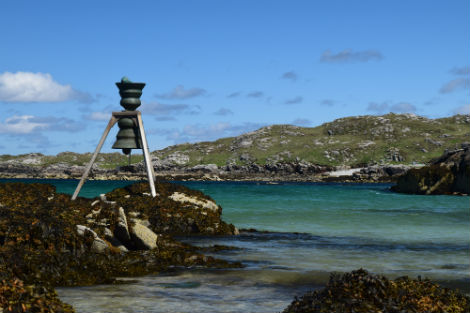
Distance: 298 km
Difficulty: 7
Method: Road cycling
Wow Factor: 9 out of 10

Key Facts

  • Location: Outer Hebrides
  • Size: 222,400 hectares
  • Terrain: Undulating road; mostly single lane
  • Access: Ferry
  • Height gain: 3460 metres
  • Starting point: For the whole Hebridean Way start at Vatersay; finish Butt of Lewis
  • Island Summary:

    We are still trying to find a route around the outer edge of Lewis. Whilst we do this we’ve included the cycling route for the Hebridean Way.

  • Route description:

    Full details here

  • Getting there:

    The main Calmac ferry to Lewis is from Ullapool on the mainland, which takes 2 hours 45 minutes. You can also travel from Skye to Harris and drive north.

Download file for GPS

Gallery