
Alderney-activity
Walking Alderney Coast Path Circuit: Route Overview and Directions
Key Facts
- Location: Channel Islands
- Size: 200 hectares
- Terrain: mostly easy coastal paths with free-range, steeper sections near Les Etacs
- Access: Ferry; Plane
- Map: Bailiwick of Guernsey, States of Guernsey Official Map
- Starting point: Braye Quay. Lat/Log 49.723970, -2.200411; GR XD 856 804
Alderney Coast Path Overview and Highlights
The dramatic walk follows a well-marked coastal trail with some steep free-range paths and remote cliff-top sections for the very best views and wildlife. It passes most of the island’s historic fortifications with plenty of opportunities to explore the forts and secret tunnels. Loaded with beach walking, spots for swimming, foreshore foraging, an optional extra island and delicious refreshments don’t be surprised if it takes all day.
The closest Channel Island to England and France, Alderney is also the least heard of and the hardest to get to. Arrival is either by small plane into the island’s tiny old-fashioned airport or by boat to the laid-back Braye Harbour. With its unhurried life and strong community spirit, possibly forged in one of the nine island pubs the locals call their second sitting rooms, along with a distinct lack of stifling rules this is a ‘live and let live’ sort of island.
Alderney Coast Path highlights
Starting in the north of the island the route passes a collection of Victorian forts and batteries that were further strengthened by the Germans in World War 2 following their occupation of the Channel Islands. Today, some of the buildings welcome visitors or are accessible for the explorer with a torch, others are derelict and requires good judgement on whether to try them or not. West of Braye the tunnels and underground rooms of the Cambridge Battery at Fort Tourgis are great to walk around, as is the expansive Fort Albert east of Braye. Further east Bibette Head, the location of a German stronghold, is a favourite for underground exploration.
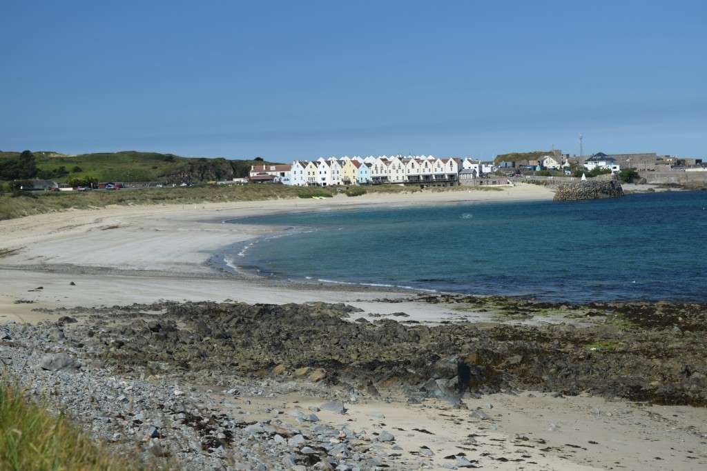
Most of Alderneys beaches are also found along the north coast of the island, with the exception of Longis Bay. The first of the favourites on the walk is Clonque Bay, home to over one hundred species of seaweed and a huge intertidal area that offers a wild sandy beach and excellent rock pooling and foraging opportunities for samphire and shellfish at low tide. Further around, at the island’s south-eastern tip, is the wide sandy crescent of Longis Bay bounded to the east by the tidal Raz Island and Fort Raz an optional excursion for the inquisitive. In the north, scenic Arch Bay is connected to Saye Bay Campsite by a small tunnel and is linked to the neighbouring Corblets Bay at low tide. Its rocks give it a secluded feel and protects the swimmer on rougher days. The family favourite beach at Braye Bay is a great way to finish the round island route, throwing hot boots off to walk the last few hundred metres on its sandy curve, with excellent restaurants and watering holes beckoning just beyond.
In the southern half of the island there is something quite different – wild heathland, woodland, dramatic cliffs, swirling birdlife and the main agricultural area producing the island’s deliciously creamy butter. First off the gannet colony (active from March to October) at Les Etacs at the western tip of the island. Best viewed after the very steep climb through the peaceful Val des Trois Vaux to Giffoine Headland, thousands of these birds live on the small guano-whitened stack. The air around is filled with their cries and plunging missile-like bodies entering the tortured waters of the Swinge tidal race. Like most birdlife on the island, and the islanders themselves, they only returned after the war.
From the west end of the island the views of Sark, Brecqhou, Guernsey and Herm, with Burhou and its puffin and storm petrol colonies in the foreground, are the best. Close by, and in stark contrast, are the ruins of Lager Sylt, the only German concentration camp built on British soil.
The coast along the stunning southern cliffs between Telegraph Bay and the long low sweep of Longis Bay is wild and inaccessible. South of the airport, on the cliff tops, the rare spotted rock rose blooms in late April and May. This small yellow plant flowers in the first sun of the day then sheds its tiny petals as the light fades in the afternoon so is a real find if spotted. Open fields, bluebell woods and cliff-top valleys lead eastwards to the Wildlife Bunker housed in the restored German radio communication centre which is packed with information about the incredible wildlife on the island. From this vantage point the French coast feels almost touchable and, for the lucky, it may be possible to spot dolphins or basking sharks in the sea below.
With its old world charm and points of interest in every nook and cranny, not to mention its culinary delights and attractions of its ‘town’, St Anne, Alderney needs at least a weekend to explore and possibly more.
Alderney Coast Path Directions
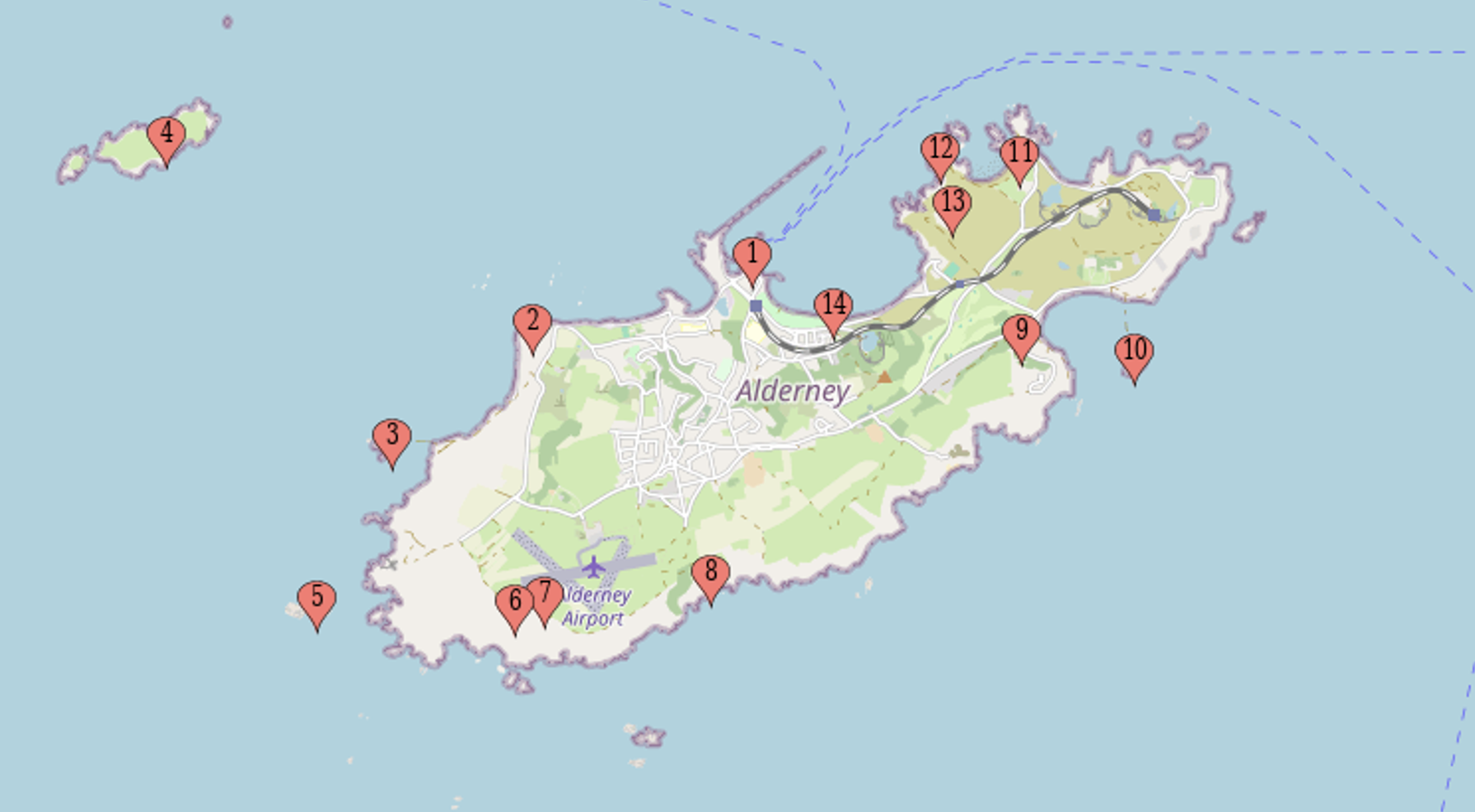
From Alderney Quay (1) turn west and follow the coastal route around Platte Saline to Fort Tourgis (2) and then the tidal Fort Clonque (3). Climb the zig-zag path above the Fort and, on a sharp left bend follow the guide rope downhill to an underground bunker. Walk over the top of the bunker, on a faint path that runs parallel to the coast and Berhou Island (4). Continue along the undulating path to then descend into the secluded Vallee des Trois Vaux with views out to Les Etacs (5).
Pass to the right of Telegraph Tower (6) and at the junction with the gravel track follow the coast path markers, passing the remains of Lager Sylt (7) on the left. Turn right on the track towards the coast and walk uphill south of the airport. Just before the top of the hill take the faint path on the right marked by a small white-painted stone. Follow the painted white rocks along the cliff top and continue along the coast path. Just before the isolated large house reach the Wildlife Bunker (8).
Reach the road that leads to the island’s rubbish tip and follow the coast path sign to Braye. After passing the telegraph buildings turn right at the road and walk downhill, past Essex Castle. The Old Barn Café (9) is on the right just before the main road. Continue around Longis Bay. At low tide crossing the causeway to Raz Island (10) is possible.
Follow the coast path marker to Braye passing the converted Fort Quesnard and the black and white Mannez lighthouse. Follow the small path to the right that takes you around Veaux Trembliers Bay around the the walls of Fort Corblets to reach Corblets Bay before passing through the tunnel to Saye Beach Campsite, toilets and café (11).
Walk through the campsite and follow the track uphill to Bibette Head (12) turn left uphill towards Fort Albert (13) and half way up the hill turn right following the coast path signs to pass underneath Fort Albert. At the top of the hill meet the gravel track that heads downhill passing the arsenal buildings to the right to meet the main island road at the bottom. Turn right and walk along the road around Braye Bay (14) to reach The Moorings restaurant. Turn right down Braye Street back to the quay.
For more details about Alderney, read our Islandeering book or download the gpx and route description below.


Join our Islandeering community
We continuously find new islands, rivers, lochs, canals and coast to walk, SUP and swim in and meet plenty of great folks along the way. Join our community to get new routes and adventures, latest blogs and news by using the email box below. Tune in also to our Facebook and Instagram pages to see where we are going next.