A circular walk around Holy Island that explores wild beaches and sand dunes of the North Shore as well as Lindisfarne Castle and Priory. The route starts with an optional walk across the glistening tidal mud and sands of ancient St Cuthbert’s Way.
Directions
Start from the island’s car park (before the island’s village), and head back up the causeway towards the mainland. After 3.4km, as the road sweeps left to cross the channel to the mainland, take the small path going North away from the causeway and walk along the base of the dunes. Continue ahead on the short grass into the dunes to reach the beach at Snook Point. Here, away from the traffic, you can drink in the peace and solitude and enjoy vistas of Berwick-on-Tweed and the domed Cheviot.
Continue along the beach of the North Shore, a vast expanse of exposed, wind-blown sand, that has been called one of the most stunning beaches in Britain yet few venture out here. Reach the first of the rocks of Black Skerrs. Bear right into the rocks, then turn right into the dunes and go through the gap in the fence. Follow the dune path parallel to the beach around Snipe Point and continue past Keel Head. The varied coastal scenery of Coves Haven and Castle Head, which has crenellated formations, caves, and ledges, can be viewed from the two secluded coves backed by the soft dunes.
Reach the obelisk at Emmanuel Head, the views from here across to the Farne Islands and fairytale Bamburgh Castle are exhilarating. Continue on the grassy path parallel to the coast to reach the stone wall after 0.5km, then cross the stile and go through the kissing gate towards the castle. Reach the beach then walk around Castle Point, keeping to right of the large stone-arched lime kilns and go up the wooden stairs to join the main path.
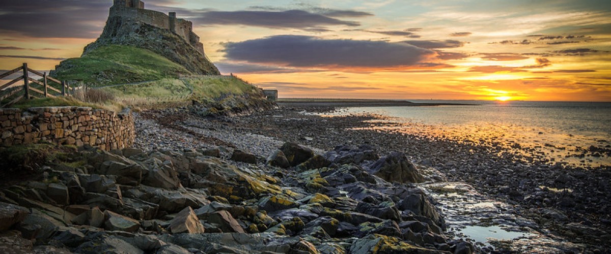
Pass to the right of Lindisfarne Castle, originally built as a Tudor fort in 1550, the castle supported a small garrison until the middle of the 19th century, when the structure fell into disuse. In the early 20th century, architect Edwin Lutyens was commissioned to create a stately holiday home within its walls. Now owned by the National Trust, the castle draws visitors like a magnet. Slightly inland, the walled garden designed by Gertrude Jekyll provides welcome respite from the crowds, its summer colours vibrant and jewel-like and is well worth a diversion.
Continue along the main track towards the village. After 600m, just before reaching the houses, turn left around The Ouse bay and pass in front of the fishermen’s sheds and upturned boats, weather-proofed with thick tar roofs and tarpaulin. At the jetty, walk up onto the bank to the right of the brown shed and lifebuoy and follow the grass track to the lookout tower – from here there are short diversions inland to visit the ruined priory. Built on the site of the original monastery that was the centre of Christian teaching in Anglo-Saxon times, the priory is an important destination for modern pilgrims. The 7th-century monk and bishop, St Cuthbert, lived here before briefly moving to the small island (now St Cuthbert’s Island) that sits close to the shore, later sailing to nearby Inner Farne for greater solitude.
Follow the wall down to the beach to pass in front of more fishermen’s sheds and continue along the coast, or visit St Cuthbert’s Island at low tide. On the shore around St Cuthbert’s Island, the rock pools are alive with crabs, sponges, anemones, starfish, pipefish, and gobies. You might even see the 15-spined stickleback, wrasse, or northern octopus in the deeper pools.
After 400m, just beyond the last shed, find a faint path on the right beside a wall and climb to the top of the bank. Continue parallel to the barbed-wire fence next to the houses. If you miss the path, continue along the beach to a bigger path up the bank, with a rope. Continue to the causeway and turn right back to the car park or follow St Cuthbert’s Way across the sands back to the mainland.
Lindisfarne’s special blue space
Lindisfarne is a National Nature Reserve, designated for its habitats and wildlife. The dunes host several nationally important plants, including 11 species of orchid including the Lindisfarne helleborine, which is found only on Holy Island. In autumn and winter the tidal mudflats host huge flocks of wintering waterfowl, which arrive from the Arctic to feed on the extremely rich supply of marine creatures and vegetation living in and on the mud – these include the rare light-bellied brent geese. As such it is important to heed all seasonal restrictions to avoid disturbing the birds from April to July. Holy Island also sits within the Northumberland Coast Area of Outstanding Natural Beauty.
Need to know
More island adventures in our book “Island Bagging England and Wales‘
Full route map: click here
Distance: 15.6km
Ascent: 255m
Difficulty: Easy
Map: OS Explorer 340 Holy Island and Bamburgh
Terrain: beach, dunes, footpaths
Start: Holy Island car park. Grid Ref. NU 125 425
Getting there: train to Berwick-upon-Tweed, then bus service. By road, leave the A1 at Beal following the signs to Holy Island. Pay car park before the village on the island. Alternatively take St Cuthbert’s Way, starting just south of the causeway bridge over South Low (see here for details)
Pitstops Fantastic coffee and cakes at The Pilgrims Coffee House, tel. 01289 389109. More info here
Find more blue space walks
Find an island adventure
Be the first to know about the latest adventures in wild blue space