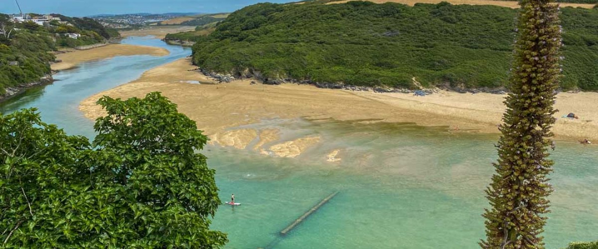
Shallow and with vibrant green-blue lagoons, the Gannel estuary is a safe family paddle on lower tides, with a stunning higher-tide option for the intrepid almost into Newquay’s centre.
This is route 23/107 in our latest book “Paddle Boarding South West England:100 places to SUP, canoe, and kayak in Cornwall, Devon, Dorset, Somerset, Wiltshire and Bristol“
Directions
Launch at the northeast end of Crantock Beach and head upstream, then immediately pass the Fern Pit ferry boathouse, taking care when paddling over the submerged footbridge at the base of East Pentire’s cliffs. Cross the mouth of Penpol Creek on the right and look out for ancient rotting vessels – the river was an important passage for the schooners and barges that ferried coal and timber up to Trevemper Bridge. Continue upstream, avoiding another hazard: the submerged Penpol footbridge for crossing the Gannel at low water. Hotels and large houses spill down the north bank of the river, with pasture and woodland on the south. On the approach to Newquay’s boating lake, glide through a peaceful salt marsh – home to wading birds and salt-loving plants. Turn around at the footbridge south of the A392 (or before depending on tide and time) then return to Crantock Beach for fresh crab and lobster from the Fern Pit Ferry Café.
The Gannel’s special blue space
Part of Newquay and The Gannel Marine Conservation Zone, the estuarine rocky habitats here are important for a range of plants and animals, including the rare giant goby. On the shores of the estuary, rocks provide a habitat for large seaweeds and barnacles, snails and shrimp-like animals. Within the estuary area, the saltmarsh is a nursery grounds for juvenile fish. Beyond the estuary below the low water mark, the rocks are home to anemones, sponges, sea mats and sea squirts, whilst the rocks and sediment away from the coast provide an important habitat, containing branching sponges, sea squirts, kelp and large seaweeds.
To help protect these special places please support Cornwall Wildlife Trust and the National Trust
Need to know
Distance 6.5km return
Access restrictions No licence required
Starting point Crantock Beach TR8 5RE. Grid ref. SW 789 611
Launching 100m walk from car park over a steep sand dune
Parking Crantock Beach Car Park (NT), Beach Road, Crantock, TR8 5RN
Pitstops Great coffee and cake from a converted army truck on the beach, Cargo Coffee, tel. 07976 238548; delicious crab sandwiches and views, Fern Pit Café, tel. 01637 873181
Lessons, hire and tours Big Green Surf School, Crantock Beach, tel. 01637 479279
Getting there Exit Newquay on A392, R at 2nd roundabout onto A3075 (Goonhavern), then R again following signs to Crantock Beach. Height restriction barrier at Crantock car park (2.1m), open when car park is attended (9am-5pm April to October). Very busy during summer; alternative private parking nearby.
Special points Full journey upriver best paddled on a spring 6m plus tide. At high tide buoys mark the position of the two underwater footbridges. Generally sheltered from a N wind, but E and W winds can funnel along the estuary. Avoid the estuary mouth where a rip current is created when tide turns or when sand bars start to appear. Crantock beach area best paddled 1.5 hours either side of high tide.
Check out more of our paddles:
Top 5 places to paddle in Cornwall
Top 5 places to paddle in Devon
Top 5 places to paddle in Dorset
Top 5 places to paddle in Somerset, Bristol and Bath
Top 5 islands to circumnavigate
South and east
Top 5 places places to paddle in the Channel Islands
Scotland
Top paddles on Scotland’s Islands
Wales
Top places to paddle on Welsh Islands
Check out our books
Check out our SUP routes of the week
Find an island adventure
Be the first to know about the latest adventures in wild blue space