The county of Somerset has some wonderful blue space with plenty of amazing places to SUP. From wild coastlines and secluded beaches to estuaries, inland lakes, rivers and canals along with paddles through World Heritage Sites – there are plenty of paddles for the beginner and seasoned paddler alike. Here we share some of our favourites that are in the most special of blue spaces (Biospheres, Marine Conservation Zones, Sites of Special Scientific Interest etc) from our new book.
Cheddar Reservoir

Wonderfully set on the southern side of the Mendip Hills this circular reservoir offers stunning views of the Somerset countryside and is a special paddle in a natural hotspot. The reservoir is fed with water from the Cheddar Yeo river in Cheddar Gorge and supplies drinking water to Bristol. Evening SUP Yoga sessions are a real highlight here with great sunsets over the western edge looking towards the Mendip Hills and Crook Peak, a distinctive feature of the Somerset landscape believed to have been a beacon site set up to signal any arrival of the Spanish Armada to the West Country coast. The reservoir is stacked with overwintering waterfowl including mallard, pochard, wigeon and goosander. Access is managed by the Bristol Corinthium Yacht Club with day membership, yoga , SUP and kayak lessons on offer. Check the book for how to get there, launching, hazards, pubs and cafes, and the best weather and sea conditions for the route, along with 14 more routes in Somerset, Bath and Bristol.
Hire & lessons SUP Yoga with Do Yoga (photo credit), tel. 07884 434710; SUP lessons with Cheddar Watersports, tel. 01934 732033
Walks nearby
Cool camping Cheddar Cheddar Bridge Touring Park, Draycott Rd, Cheddar BS27 3RJ; tel. 01934 743048 or Petruth Paddocks, Labourham Drove, Cheddar, BS27 3FS; tel. 01934 257055
Why is Cheddar Reservoir a special blue space
Cheddar Reservoir is a Site of Special Scoentific Interest (SSSI) due to its wintering waterfowl populations. Look out for mallard, gadwall, tufted duck, common pochard, Eurasian widgeon, common goldeneye and goosander with the occasional rarity blown in during storms.
To help protect these special places support Somerset Wildlife Trust and the National Trust
Porlock
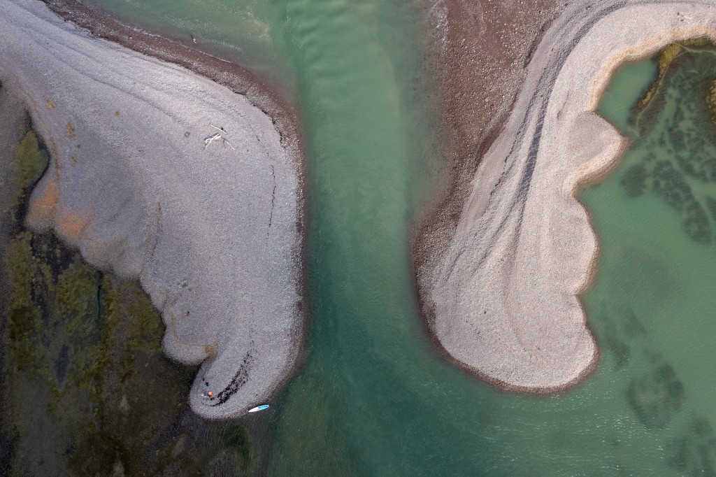
Sheltered paddling in the ancient harbour of this highly picturesque coastal hamlet with scenic trips in the bay and high tide exploration of beautiful salt marshes. At mid to high tide launch off the beach close to the harbour and enter the main dock through the ‘lock’ gates to explore the marsh area and admire the row of charismatic thatched cottages of ‘Turkey Island’. Alternatively head east and follow the shingle ridge as it extends towards the heather-clad flanks of Hurlstone Point. There are great views across the Bristol Channel to South Wales and inland to dramatic hillsides and deep, wooded combes that rise to meet Exmoor National Park. To get up close to marshland wildlife enter ‘The Breach” on a Spring high tide. This gap in the shingle, formed after a storm in 1996, transports you to a different world. Here the trunks and branches of trees stand frozen in time by salt water that broke through the breach and altered this previously farmed land and its vegetation forever. Now sea lavender, glasswort and sea purslane thrive in the briny environment of ponds and natural creeks that wind their way through the saltmarsh. Rich in bird life that gorge on the worms and shrimp that inhabit the muds here egrets, oystercatchers, redshank and shelduck are often spotted along with spring and autumn migrants such as osprey, turnstone or spoonbill. There are plenty of tasty post-paddle treats in the village, along with succulent Porlock Bay oysters. Check the book for how to get there, launching, hazards, pubs and cafes, and the best weather and sea conditions for the route, along with 14 more routes in Somerset, Bath and Bristol.
Tours and lessons Exmoor Adventure, Porlock Weir, tel. 01643 805001
Walks nearby
Cool camping Porlock Borrowhayes Farm, West Luccombe, Minehead TA24 8HT; tel. 01643 862463
Why is Porlock a special blue space
Porlock Ridge and Saltmarsh is a Site of Special Scientific Interest (SSSI). The shingle ridge was breached during storms in 1996. The lower saltmarsh is host to a number of plants including glasswort, sea-blite, sea aster, sea purslane, common saltmarsh-grass and spear-leaved orache. On areas of slightly higher saltmarsh, sea plantain, sea arrowgrass and sea milkwort also occur. On shingle areas which are not inundated by salt water saxicolous lichens cover the pebbles along with the nationally rare fungi – Rinodina aspersa – and the nationally scarce fungi – Buellia subdisciformis, Caloplaca arnoldii and Lecanora subcarnea. On the back face of the ridge and on shingle deposited to the landward side of it communities of higher plants are found including upright chickweed, sea storksbill, bird’s-foot clover and subterranean clover. Also found here is the nationally scarce Babington’s leek. Along with grey heron, little egret and shelduck, winter flocks of lapwing, curlew, teal and shelduck the site is also visited by a very wide range of migratory species.
To help protect these special places support Somerset Wildlife Trust and the National Trust
Uphill Lake
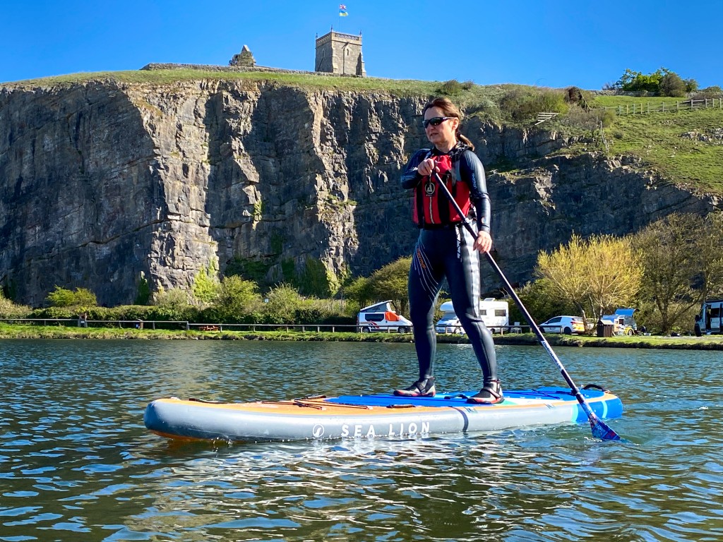
A blissful tiny private lake that sits beneath a limestone quarry face. Perfect for families or those honing paddling skills. There’s also camping, good local food and walks to the beach. Located in a marina, the lake was once part of the medieval port of Uphill when Bristol Channel coasting vessels sailed up the River Axe. They unloaded their coal, salt, and gunpowder to return with locally made bricks, lime and timber. Today it makes a relaxing spot to float around in and enjoy the views to Brean Head or watch climbers scale Uphill Quarry. Set within a nature reserve there are plenty of insects and wildflowers to spot especially around the quarry floor where knapweed, honewort, vetches, autumn gentians can be found along with springtime primroses, cowslips and green winged orchids. The lake is located along two great walks – the Brean Down Trail and the Tidal Trail. The hill behind the quarry can be walked up to enjoy fantastic sunsets, views to Brean Down and to visit 11th Century St Nicholas Church and its traditional beacon known as The Tower. Weston-Super-Mare is a thirty minute stroll away. Check the book for how to get there, launching, hazards, pubs and cafes, and the best weather and sea conditions for the route, along with 14 more routes in Somerset, Bath and Bristol.
Walks nearby
Cool camping Weston Uphill Wharf Campsite & Marine Centre, Uphill Wharf, Weston-Super-Mare, BS23 4XR; tel. 01934 418617
Why is Uphill Lake a special blue space
Uphill Lake sits in the Uphill Hill which is a Local Nature Reserve, a Site of Special Scientific Interest (SSSI), and part of the Mendip Limestone Grasslands Special Area of Conservation, (SAC) supporting a diverse flora and valuable insect habitat. The site lies on carboniferous limestone, which has been formed into a sheer face by quarrying at the western edge. A very diverse flora is found on the rock ledges of the disused quarry and steeper slopes of the Hill. An outstanding display of cowslips, primroses and green winged orchids covers the northern and eastern hill slopes in the Spring. The rest of the site is more level and gently sloping and consists of semi-improved calcareous grassland. Check the book for how to get there, launching, hazards, pubs and cafes, and the best weather and sea conditions for the route, along with 14 more routes in Somerset, Bath and Bristol.
To help protect these special places support Somerset Wildlife Trust and the National Trust
City of Bath
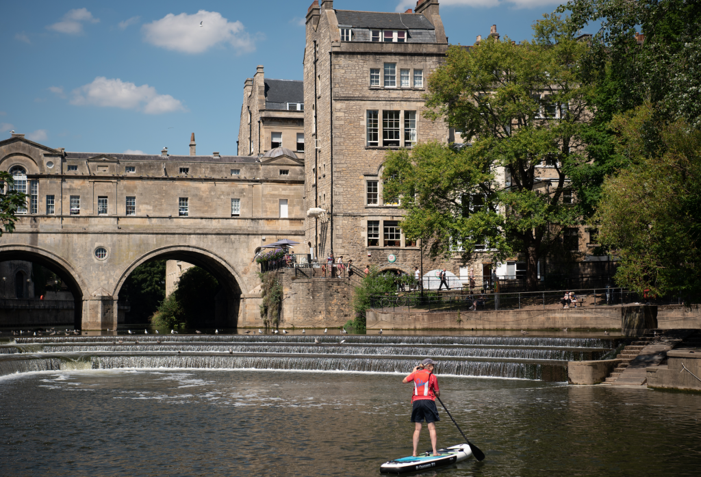
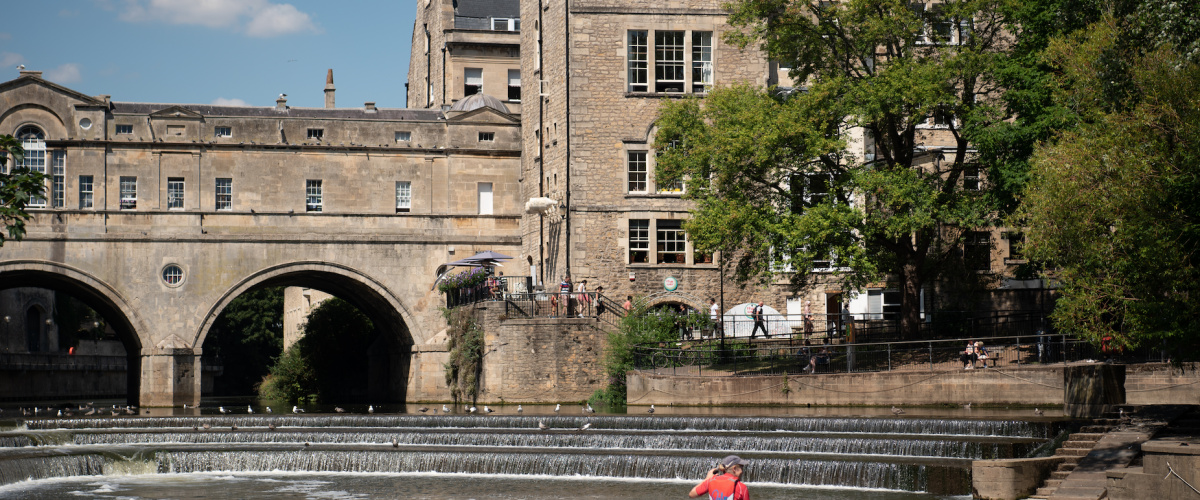
Unique river-level perspective of the city’s famous honey-coloured Georgian architecture on a 3.7km paddle through the city’s industrial heart to the spectacular Pulteney Weir and Bridge. Start on the jetty alongside Weston Lock and paddle 250 metres along the Weston Cut past the Locksbrook Inn to join the River Avon. The river takes a wide meander, its banks a mix of green space, reclaimed buildings and warehouses with cyclists whizzing along the Bristol and Avon Railway Path that runs parallel for most of the route. At the suspended Victoria Bridge The Riverside Complex on the south bank offers a good coffee stop with easy exit on the bank just beyond the footbridge. Continue towards the city centre past quays used by tour boats then pass under the main road and rail bridges. The lock gates of the Kennet and Avon Canal can be spotted on the right as the river turns to the left. Views open of the spire and riverside garden of the large Victorian Catholic Church and, after the arch of North Parade Bridge, the colour and greenery of Parade Gardens gives way to the spectacular Pulteney Bridge and Weir. Approach the horseshoe-shaped weir for unique views of the colonnades, vaults and Pulteney Bridge, one of only four bridges worldwide with shops across the full span on both sides. To dip in the warm waters that first made Bath popular with the Romans paddle up to edge of Parade Gardens to find a hidden outlet from the Spa, the extra river weeds growing in its vicinity are a giveaway. Check the book for how to get there, launching, hazards, pubs and cafes, and the best weather and sea conditions for the route, along with 14 more routes in Somerset, Bath and Bristol.
Tours Bath City tours with Original Wild https://www.originalwild.com/stand-up-paddleboarding-in-bath/ tel. 01225 582181
Walks nearby
Cool camping Bath Tuckers Grave Inn and Campsite, Faulkland, Bath, Radstock BA3 5XF; tel. 01225 962669
Why is Bath a special blue space
The City of Bath is a UNESCO World Heritage Site inscribed for its Hot Springs, Roman archaeology, Georgian buildings and natural landscape setting.
To help protect these special places support Somerset Wildlife Trust and the National Trust
Bristol Floating Harbour
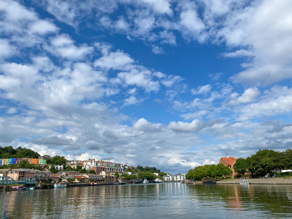
A chilled way to see the highlights of Bristol Harbourside with optional excursions along the feeder waterways. The Floating Harbour earnt its name from the fact that the harbour’s water remains at a constant level and is not affected by the huge tidal range of the Bristol Channel. The lock system, sluices and pump house were built in the 1770’s to circumvent the tide for this once busy cargo destination. Today the old wharf buildings and engineering sites have been converted into multiple attractions. Launch at the Baltic Wharf slipway and explore to your heart’s content. Highlights include Underfall Yard, the old hydraulic pumping station has been converted into a museum and café. There are several further museums and galleries on the water’s edge and a number of historic boats moored outside the M Shed including the steam tug Mayflower, fire-float Pyronaut, motor tug John King, and a replica of John Cabot’s ship The Matthew. The jewel in the crown though is Isambard Kingdom Brunel’s SS Great Britain and the unique perspective you get of it from the water. To extend the trip the Bristol Harbour Licence continues upstream on the River Avon as far as Hanham Lock. Check the book for how to get there, launching, hazards, pubs and cafes, and the best weather and sea conditions for the route, along with 14 more routes in Somerset, Bath and Bristol.
Hire, lessons & trips SUP Bristol https://www.supbristol.com tel. 0117 4225858
Walks nearby
Cool camping Bristol The Stables Campsite, A431 Bath Rd, Fieldgrove Lane, Bristol BS30 6HU; tel. 07804 621161
Why are Bristol Docks a special blue space
Part of the City Docks Conservation Area in the centre of Bristol, whose wharves are very much part of the city shaping Bristol’s sense of place as a great maritime city. Lots of listed buildings, a Scheduled monument (Underfall Yard) and historic vessels. Bristol is also a UNESCO designated Creative City for Film.
To help protect these special places support Somerset Wildlife Trust and the National Trust
Check out other top places to paddle UK
England
South west
Top 5 places to paddle in Cornwall
Top 5 places to paddle in Devon
Top 5 places to paddle in Dorset
Top 5 places to paddle in Somerset, Bristol and Bath
Top 5 islands to circumnavigate
South and east
Top 5 places places to paddle in the Channel Islands
Scotland
Top paddles on Scotland’s Islands

