Sark, Guernsey

About Us

Hi and welcome to Islandeering Islandeering is for people who want adventure in Britain’s wild blue spaces – our rivers, coast, lakes, canals and islands. You will find amazing walks, paddles and swims in the UK’s most special places, those recognised for outstanding natural beauty, incredible geology or special and abundant wildlife.
Learn More

Join our Islandeering community

We continuously find new islands, rivers, lochs, canals and coast to walk, SUP and swim in and meet plenty of great folks along the way. Join our community to get new routes and adventures, latest blogs and news by using the email box below. Tune in also to our Facebook and Instagram pages to see where we are going next.
High Point: Le Moulin, 108 metres
Population: 500
Size: 544 hectares
Wild Factor: 8 out of 10

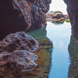
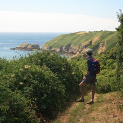
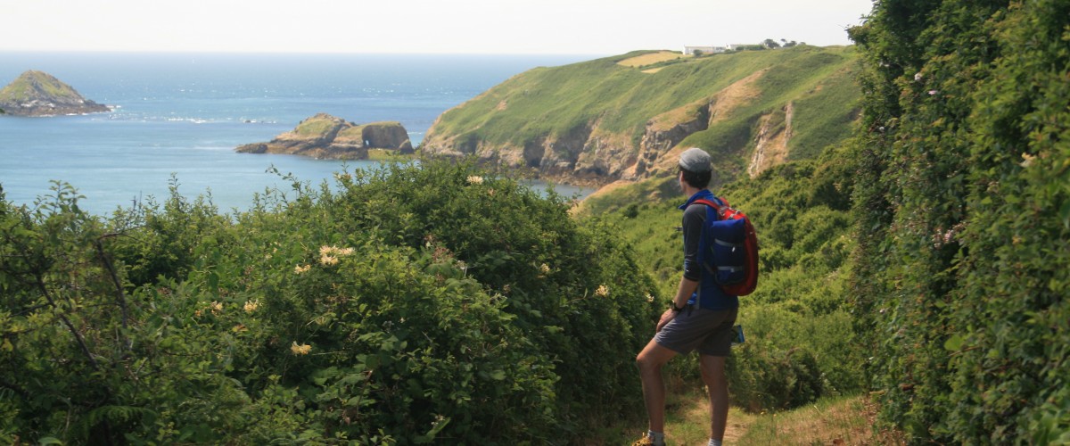
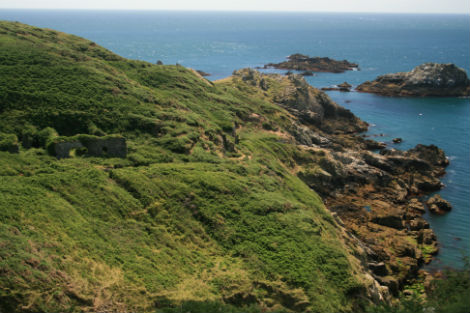
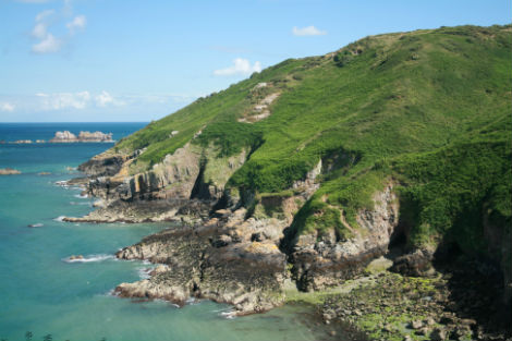
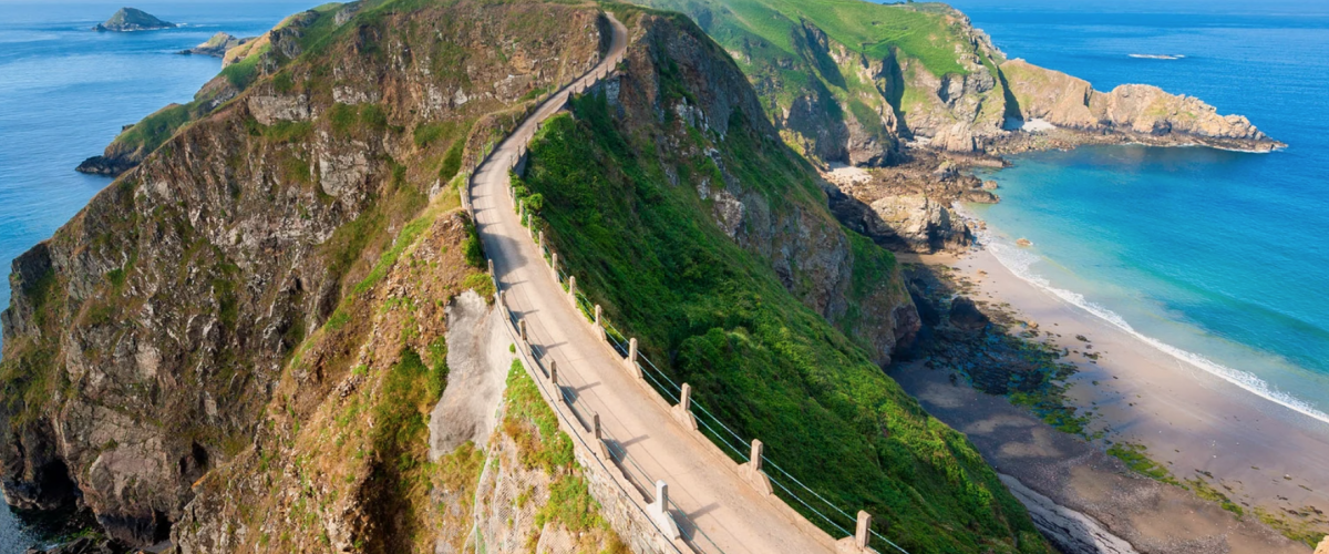
Overview of Sark: Quirky and timeless, Sark’s coastline is packed with caves and swimming spots and the night sky spangled with stars. Sark bills itself as a ‘world apart’ and sometimes it does feel like it’s in a bit of a time-warp as there are no cars and the only transport is by bike, tractor or horse-drawn cart. It has its own parliament and it was one of Europe’s last feudal states. Although most visitors come here to relax, there is plenty of outdoor adventure along the steep cliffs, coves, gullies and caves and there are some excellent beaches to explore including Dixcart Bay, Port Moulin and La Coupée along with plenty of places for wild swimming specially Le Creux harbour and the famous natural Venus Pool and Adonis Pool. There are sporting and cultural festivals throughout the year that range from Sarkfest to Sheep and Lawnmower racing. The second smallest inhabited island of the Channel Islands

Type of island: inhabited

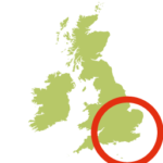
Location: Bailiwick of Guernsey, Channel Islands

Sark’s highpoint: Le Moulin, 108 metres

How to get to Sark: Sark is accessed by a regular 1 hour boat ride from Guernsey with the Sark Shipping Company or weekly Manche Ile Express from Jersey

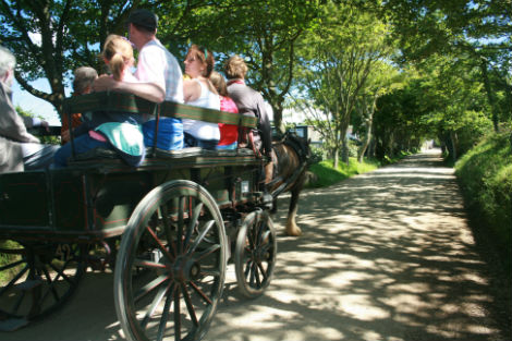
Getting around Sark: Sark is free from cars and vehicles, except tractors, so walking, cycling or a horse-drawn carriages are the transport options. On this island everything is within walking distance from the village. You can also hire a bike from Avenue Cycle Hire or A to B Cycle

Best time to go to Sark: the best months for good weather in Jersey are June, July, August, September and October with the warmest months being July, August and September. The coldest months are January and February and the rainiest are January, October, November and December. The best months for swimming are August and September. The not-to-be-missed Sark Fest is usually in July

Dog friendly Sark: Sark is dog friendly with restaurants and accommodation permitting dogs. Interestingly the only pet restrictions are that it’s illegal to keep an unspayed bitch on the Island for more than 28 days.

Food and drink on Sark: Sark has a great selection of places to drink and eat from fine dining, to quality restaurants and cafes, with plenty of island-grown food to enjoy.

Accommodation on Sark: Sark’s accommodation rages from camping and glamping to high quality hotels, guest houses and self-catering cottages. More information here

Contacts: Sark Tourist Office Tel: 01481 832345 or email office@sark.co.uk.

Best things to do in Sark: 

  • Swim in the Venus Pool and Adonis Pool
  • Explore the amazing caves
  • View through the window in the rock
  • Exploring beautiful beaches

Other islands nearby:

Jersey – more info here

Alderney – more info here

Herm – more info here

Guernsey – more info here

Caving Sark

Discover the hidden wonders of Sark's caves

Learn More

Walk Sark's coast path

Walk Sark's coast path

Learn More
Sark, Guernsey

About Us

Hi and welcome to Islandeering Islandeering is for people who want adventure in Britain’s wild blue spaces – our rivers, coast, lakes, canals and islands. You will find amazing walks, paddles and swims in the UK’s most special places, those recognised for outstanding natural beauty, incredible geology or special and abundant wildlife.
Learn More

Join our Islandeering community

We continuously find new islands, rivers, lochs, canals and coast to walk, SUP and swim in and meet plenty of great folks along the way. Join our community to get new routes and adventures, latest blogs and news by using the email box below. Tune in also to our Facebook and Instagram pages to see where we are going next.
Distance: 17.3 km
Difficulty: Challenging (if on a day-trip)
Method: Walking
Wow Factor: 8 out of 10

Key Facts

  • Location: Sark, Channel Islands
  • Size: 545 hectares
  • Terrain: Good paths
  • Access: Ferry
  • Height gain: 483 metres
  • Map: Bailiwick of Guernsey; States of Guernsey Official Map
  • Starting point: Creux Harbour
  • Accommodation/food:

    Sark has a full range of accommodation from camping to high quality hotels

  • Island Summary:

    A steep-sided island with dramatic cliffs and few beaches, topped by a plateau of luxuriant small fields stitched together by miniature woodlands and wildlife-filled hedgerows there are plenty of great walks on Sark. A favourite is the Sark Coast Path around the whole island where most of the island’s natural and cultural attractions may be seen.

  • Look out for:
    • Venus pool in Little Sark
    • The Window in the Rock in the side of the headland at Port du Moulin
    • Stargazing
    • Exploring the caves
  • Route description:

    The Sark Coast Path starts as you exit the tunnel after disembarking the ferry at Creux Harbour. The walk climbs immediately onto the island’s plateau for great views of Creux Harbour before skirting Derrible Bay and plunging towards Dixcart Bay with an optional descent to the beach.

    Back on the plateau the route crosses the spectacular La Coupee and circumnavigates Little Sark. Here the ruins of silver mines can be explored and there is an opportunity for a dip in the amazing tidal Venus Pool.

    Back on to the west coast of Great Sark with its agricultural fields there are  good views across to the privately-owned Brecqhou. Heading inland for the first time the route uses one of the main island ‘streets’ where cafes, supplies and island attractions are plentiful. Turning north, the warren of paths on Eperquerie Common make navigating interesting, with many leading down to the caves before finally heading south and skirting the main part of ‘town’ to reach Creux harbour.

  • Getting there:

    Sark is accessed by a regular 1 hour boat ride from Guernsey with the Sark Shipping Company or weekly Manche Ile Express from Jersey

List   

Information
Click following button or element on the map to see information about it.
Lf Hiker | E.Pointal contributor

NO NAMED GPX   

Profile

50 100 150 200 5 10 15 Distance (km) Elevation (m)
No data elevation
Name: No data
Distance: No data
Minimum elevation: No data
Maximum elevation: No data
Elevation gain: No data
Elevation loss: No data
Duration: No data

Description

Sark A014-07-13 16_40_50

Gallery