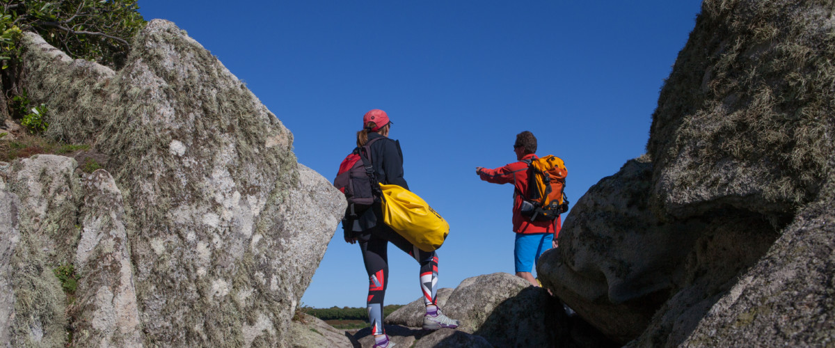
Looking for some wild blue space? How about an island adventure. A walk around an island couldn’t be simpler – keep the sea to your left and just keep going. Ultimately it’s impossible to get lost, and you’ll always end up back at the beginning. There are 15 islands around the English coastline that have recognised circular walks around their perimeter. Some are really challenging, whilst others make for easy, relaxed walking with plenty of pitstops and interest on the way. Here are some of our favourites.
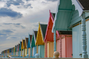
Walk St Mary’s, Scilly
Distance: 16 km | Ascent: 497 metres | Start: Hugh Town
The very minute you step off the plane or boat upon arrival to this island you can’t help but soak up its wonderfully bucolic feel. The walking route starts at Hugh Town, explores the historic fortification of the Garrison, the café-lined promenade of Porth Cressa, and then the oddly-shaped rocks of Peninnis Head. On the south coast, Old Town provides an opportunity to see Harold Wilson’s grave at the church and to stock up with refreshments at the café. Passing the end of the airport’s runway on Salakee Down can be quite exhilarating with an impending arrival indicated by a siren. Rounding Porth Hellick Bay, with its small fishing boats, the burial chambers can be viewed using a small diversion from the path, before reaching the beautiful sands of Pelistry Bay. Further along the stunningly located Innisidgen burial chambers are well worth poking your head into before heading into the tall pines of Helvear Down, and the high point of the island at telegraph. After passing Bar Point, the views of Tresco open up and as you approach the bobbing boats in Hugh Town’s harbour you feel like you are returning to civilisation. Further details and GPX here
Walk St Martin’s, Scilly
Distance: 14.2 km |Ascent: 330 metres| Start: Lower Town Quay
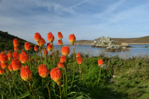
With some of the best beaches in the world, tantalising crystal clear waters and a sense of calm that will wash over and soothe the most restless of souls, St Martin’s is our favourite islands. After completing this walk if the water doesn’t tempt you, the mouth-watering local food definitely will. Starting at Lower Town Quay the path affords great views over the uninhabited, rocky Teän with St Helen’s behind before reaching the boulder-strewn Pernagie Point. At low tide, White Island can be accessed via White Island Bar and a circumnavigation of this islet is possible on its faint paths. An easy coastal path then passes the extensive beaches of Great Bay before climbing up towards the Daymark and St Martins Down, from where Land’s End can be seen on a good day. Descend towards Higher Town, where refreshments are available, before taking the grassy, sandy tracks that pass through the flower fields and marram-covered dunes back to Lower Town Quay. Further details and GPX here
Walk Tresco, Scilly
Distance: 10.4 km |Ascent: 201 metres |Start: Carn Near Quay
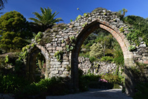
Tresco with its Caribbean-style beaches, sparkling turquoise sea and sub-tropical plants is usually a destination for those seeking more of a luxury resort but it also paradise for walkers. The south of this island is genteel, whilst the north is rugged moorland. There’s a mysterious sea-cave to explore, romantic coastal fortifications and tranquil views all around. The best of everything can be seen by walking Tresco’s coast path. The walk starts at Carn Near Quay (an alternative is New Grimsby Quay, depending on tide height and where the ferry drops you off). The easy estate ‘road’ through New Grimsby soon turns into a narrower, bracken-covered path to Cromwell’s Castle on the boulder-strewn shore before ascending to the ruins of King Charles’ Castle. From here the views are extensive – reaching Land’s End to the east and Bishops Rock Lighthouse to the west with all of the islands in between. The route then climbs Gun Hill in the north of the island and crosses the heather-clad moor via the sea-cave at Piper’s Hole to reach the delightful, castaway-café of Ruin Beach. After refreshments the grassy path south follows the bone-white beaches to reach the dune-backed Pentle Bay, named in the top ‘Under-the-Radar’ beaches by the Wall Street Journal. The route back to Carn Near Quay affords plentiful views of Abbey House and, if time permits, many options for a detour to visit the world-renowned sub-tropical garden and wildlife-rich Abbey Pool. Further details and GPX here
Walk St Agnes, Scilly
Distance: 7.7 km | Ascent: 132 metres | Start: The Quay
This wild, rugged island sits on the outer edge of the British Isles. This circumnavigation places you almost within touching distance of the fearsomely jagged Western Rocks and the swirling bird colonies of the uninhabited Annet. The route starts at the Quay and immediately passes The Bar across to Gugh, then explores the heathery slopes and fantastical granite outcrops of Wingletang Down. The north east coast leads to Troytown Farm and campsite, a great opportunity for refreshments before a walk out to Burnt Island and then on around the north part of the island to return to the Quay. Further details and GPX here
Walk Bryher, Scilly
Distance: 8.2 km | Ascent: 181 metres | Start: The Quay
A straightforward, and inspiring route that takes in the ancient cairns of Shipman Head Down and the notorious Hell’s Bay. The coast path ‘climbs’ the island’s three small hills and descends into most of its coves and beaches. Starting at Church Quay the old bulb fields and quaint cottages of Old Town lead to the popular Fraggle Rock Bar before heading into the wilds of the moorland of Shipman Head Down and one of the largest Bronze Age burial sites in northwest Europe. Rounding the northern tip, the west coast is dramatic with the aptly named Hell Bay exposed to the full power of the Atlantic. Heading south the landscape becomes much gentler at Stinking Porth, around the Hell Bay Hotel, with the brackish and calm waters of Great Pool a magnet for migrating birds. The path climbs again to reach the westerly points of Gweal Hill and Heathy Hill with Droppy Nose Point, a charismatic rock formation and a favourite haul out site for seals. The south coast then becomes flatter with the sands of Rushey Bay before skirting around the base of Samson Hill, and gently returning to the Quay. Further details and GPX here
Walk Lundy Island, Devon
Distance: 14.3 km | Ascent: 600 metres | Start: Landing beach
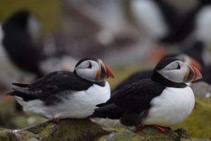
Lundy sits where the Bristol Channel meets the Atlantic Ocean, and is a popular destination for day-trippers and those seeking peace and nature. Owned by the National Trust and operated by the Landmark Trust, the whole island is a working farm with plenty of accommodation, its own pub and store. The unmarked coast path leads from the landing beach and heads north up the ruggedly beautiful east coast, with great views across to the mainland moors and harbours, to the seal colony at Gannets Rock. On reaching the open grassland and heath of northern tip, views of the whole island can be seen stretching to the south. Walking along the western coast, its rock features that are a climber’s Mecca, take the full force of the Atlantic. The puffins here are great to watch in season, and Battery Point is a great place to explore more of the island’s history. The walk along the south coast passes the remains of Marisco castle and then heads into ‘town’ for some well-earnt refreshments. Further details and GPX here
Walk the Isle of Wight
Distance: 112 km | Ascent: 2092 metres |Start: Cowes
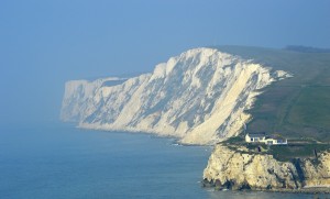
An iconic holiday island, and a popular destination for its outdoor activities and cultural attractions the Isle of Wight’s coastal path is the most challenging in this article. It can be completed in a single day as part of an organised charity challenge walk or over several days, making the most of some great places to stay and an excellent bus service to get you to and from your daily start/end points. The route is very varied and includes chalk and sandstone cliffs, walking through popular holiday towns and villages and less crowded inlets, bays, marshes and saltings as well as its unique chines. It passes most of the iconic Isle of Wight sights including The Needles, Freshwater Bay and many charming villages. Further details and GPX here
Walk Brownsea Island, Dorset
Distance: 8.9 km | Ascent: 133 metres | Start: Brownsea Island quay
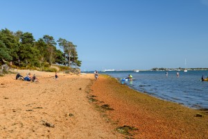
A walk around Brownsea Island follows easy paths through the island’s pine-woods, heathland, sandy beaches, meadows, lakes and lagoons which are all are crammed with flowers and wild creatures. It isn’t surprising that this island was voted the best nature reserve in the UK. Throughout this walk there are stunning views north and east to Poole and Sandbanks, and the Purbeck Hills and chalk stacks of Old Harry’s Rocks to the south. With plenty of access to beaches for swimming and exploring the foreshore, there is too much to do in a single visit. Further detail and GPX here
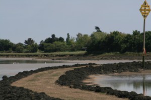
Walk Thorney Island, West Sussex
Distance: 13 km | Ascent: 54 metres | Start: Emsworth
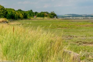
Thorney is owned by the Ministry of Defence and the resultant lack of commercial development on the island makes the saltmarshes and creeks of Chichester Harbour a wonderful haven for wildlife and people alike. The easy coastal path is part of the Sussex Border Path and follows the Thorney and Emsworth Channels that enclose the secretive military interior. There are fabulous views of the whole expanse of Chichester harbour, and the wild sandy beach at the southern tip is a great place for a swim. Access is via MoD security gates. Further details and GPX here
Walk Isle of Dogs, London
Distance: 7 km | Ascent: 70 metres | Start: Canary Wharf River Bus Stop
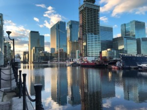
This circular London walk offers real breathing space within the City. Although the island is under rapid development, the clatter of haulage equipment raising cement through the multi-colour jungle of high rise skeletons is muted by the calm waters of the Thames that gracefully meander towards the sea. Grebes, gulls and people alike enjoy the escape it offers from the frenetic urban forest. There are two very different worlds here and both are very enjoyable. There is plenty of green space on offer with the Sir John McDougal and Island Gardens and Mudchute farm a short deviation from the Thames Path. There’s lots of fascinating history with the Docklands Sailing Centre and old wharf buildings once the centre for chemicals, paints, drugs and oils, as well as the Ferry House Inn, the oldest building on the island. The view from the Isle of Dogs to Greenwich is one of the best in London and the famous landmarks of the glass dome at the south entrance of the foot tunnel, the wooden masts of the Cutty Sark, the majestic buildings of Greenwich Hospital and the parkland with the Royal Observatory on the hill top can easily be picked out across the river. Further details and GPX here
Walk Mersea Island, Essex
Distance: 21.5 km | Ascent: 50 metres | Start: West Mersea
This is a gentle walk around the UK’s most easterly inhabited island, surrounded by silent tidal creeks and estuaries that are packed with wading and migratory birds. Starting at the village of West Mersea the clockwise route quickly gets wilder as it follows the sea wall along the north coast alongside the Strood and Pyefleet Channels. Rounding the eastern tip of the island it passes the low small Jurassic cliffs and woodland of Cudmore Grove Park. Sand and shingle beaches, front gardens of holiday parks, large houses and colourful beach huts then dominate the south coast route return route. Famed worldwide for its native oysters this island is a destination for seafood lovers that boasts its own vineyard and brewery. Further details and GPX here
Walk Northey Island, Essex
Distance 6.3 km | Ascent 28 metres | Start Maldon Parade Recreation Carpark
A wild National Trust-owned island a stone’s throw from the historic town of Maldon in the Blackwater River estuary. Access is via the tidal causeway (2 hours either side of high tide). The views of the mudbanks either side of the causeway are fantastic. Once on the island there is an easy lane to follow to the Warden’s Cottage (small charge for island access). There is a gap in the hedge on the left just before the cottage (signed ‘Private’) to reach the path that then follows the perimeter of the island back to the causeway. Further details and GPX here
Walk Scolt Head Island, Norfolk
Distance: 13.8 km | Ascent: 243 metres |Start: Burnham Overy Staithe
Scolt Head Island is full of outdoor adventure, internationally important birdlife and vast sand or shingle beaches. The walk to the island and around it will appeal to adventurous families, birdwatchers and wild swimmers alike. There are a number of options for this walk depending on the level of adventure you’re after. The full circumnavigation is definitely for those who love mud and splashing around in water. You’ll cross two tidal creeks to get to the island from Burnham-Overy-Staithe, then wade along the main channel around the southern length of Scolt Head. Most of the creeks will be water-filled even at low tide but are easy to wade through at ankle to knee height. The full route continues to the western tip (out of bounds due to nesting terns from April to August) before returning along the north shore with its miles of wild sand dunes and shingle. A shorter route cuts to the north shore before the western tip. To avoid wet feet completely, there is a seasonal ferry from Burnham Overy Staith for a beautiful and wild walk along the north shore. Further details and GPX here
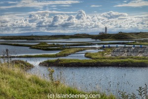
Walk Holy Island of Lindisfarne, Northumbria
Distance: 15.6 km | Ascent: 255 metres | Start: Holy Island carpark

Follow in the footsteps of ancient pilgrims to soak up the spiritual vibe of Holy Island. Described as the cradle of Christianity in England it was the chosen site for converting pagans to Christians and transforming a nation. From the island’s carpark the route heads back along the causeway, around the dunes at Snook Point and then along the whole wild beach of the island’s north to sandy paths of The Link. It passes Lindisfarne Castle and the rustic boatsheds of The Ouse to reach the historic Priory ruins before following the low cliff-top path back to the main car-park. The more authentic way of reaching the island is to walk the Pilgrim’s Way across the tidal sands. Further details and GPX here
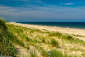
Walk Walney Island, Cumbria
Distance: 36 km | Ascent: 249 metres | Start: Earnse Point, North Walney
Some of Cumbria’s most spectacular coastline on the England Coast Path can be found on Walney Island. The circular coastal walk is full of glorious beaches, dunes and saltmarshes, wonderful wildlife and dramatic views of the Lakeland Fells in the north and the wide expanse of Morecombe bay in the south. South Walney is especially important to a wide number of migrating birds and is home to the Walney Bird Observatory – as well as a large colony of seals. The walk along the island’s west coast follows an 18 km strip of wide sandy beaches, dunes and impressive views across the Irish Sea, whilst the walk along the east coast faces the Walney Channel and vast stretches of precious salt marsh. Further details and GPX here
Walk Piel Island, Cumbria
Distance: 1.1 km | Ascent: 8.8 metres | Start: Piel Island Jetty
With a traditional inn, a short row of houses, a beach, lake, great wildlife, medieval castle ruins and a short boat trip or walk from the mainland Piel Island is a near perfect island. Add to that the views that stretch from Barrow, the peak of the Old Man of Coniston in the lake District, to the vast stretch of the Fylde coastline to the Blackpool Tower – all of which can be seen from the island’s beautiful coastal walk. Further details and GPX here
There is something very special about walking around a whole island. Yes, it is bagging of sorts – but in a slow way. Walking is the best way to see the highlights that each one has to offer; to experience the difference in life and landscape at high and low water; to chat to the islanders and try some of their delicious island food. Our islands are places of great wilderness, they offer incredible blue space to unwind and never before have so many of us needed just that.
Check out our books
Find more blue space walks
Find an island adventure
Be the first to know about the latest adventures in wild blue space